City of Greeley: Arroyos del Sol Natural Area Site Plan - Planning Excellence Award

The site plan for Arroyos del Sol represents the culmination of a 30-year effort to acquire one of the last large parcels of land in the region suitable for conservation and recreation. The 2022 acquisition of the property by Trust for Public Land (TPL) and 2025 plan for the natural area reflect the tenacity and dedication of The City of Greeley’s Natural Areas & Trails Division (city) staff to continuously pursue grants, build strategic partnerships, and raise awareness and support from the community for the conservation of open space.
A commitment by the city and TPL to connect residents to nature ensured community voices were at the center of the planning process. More than 4,100 stakeholders, partners, and residents guided the development of this plan and revealed a collective desire to preserve Arroyos del Sol's natural character, integrate conservation with opportunities for recreation and place-based programming, and ensure access for all visitors.
Arroyos del Sol is envisioned as a conserved natural area supporting biodiversity, wildlife habitat, and recreation. Its bluffs, arroyos, shortgrass prairie, and riparian ecosystems are critical to the resiliency of Arroyos del Sol and the larger ecological corridor of the Cache la Poudre River.
The planning framework for Arroyos del Sol is predicated on a balance of conservation and visitor use. Analysis built on Colorado Natural Heritage Program botanical and zoological surveys and a baseline inventory of natural and cultural resources to identify areas critical for conservation and areas of existing disturbance suitable for low-impact visitor uses and habitat restoration. Roundtables, surveys, work sessions, and site walks with city staff, TPL staff, technical experts, the International Mountain Biking Association, Colorado Parks and Wildlife, and recreation and conservation stakeholders further guided this analysis and informed the development of a shared vision, site program, audience, and site alternatives.
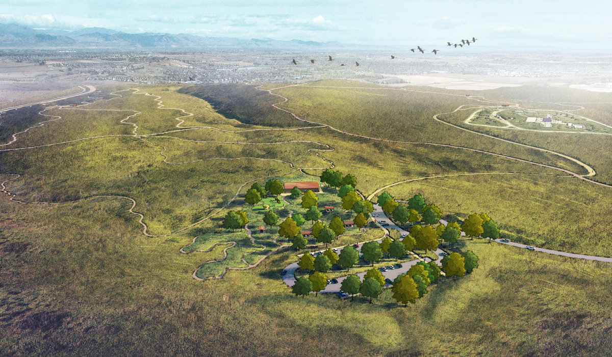
Trailheads and visitor hubs with higher use are clustered in small, defined areas of previous disturbance (agricultural fields, gas and oil sites) to maximize conservation of prairie and riparian vegetation. These visitor use areas are sited to be subordinate to the prairie landscape, capitalize on prairie and mountain views, and offer settings for visitors of all ages and abilities to explore, engage, find solitude, and connect with the natural world of the shortgrass prairie.
A comprehensive network of trails and access points establishes welcoming entrances, safe and intuitive routes for all modes, and connections to regional trails, surrounding communities, and public transportation systems. The 12-mile trail network creates moments of discovery beginning at the entrances to Arroyos del Sol and continues through the natural area. A wide hike/bike trail provides an accessible route along the top of bluffs, singletrack hike/bike trails provide diverse experiences of varying degrees of challenge, and mountain bike and bike skills trails provide opportunities for cyclists of all abilities to improve their skills.
Landscape typologies presented in the plan promote biodiversity, healthy habitats and ecosystems, and resiliency. The typologies are intended to evolve and provide baseline guidance for visitor use, restoration, management, and areas of future study and documentation.